


How 3D Scanning maps mines and plants in fine detail
In the world of traditional surveying, the measurement of critical infrastructure can be time-consuming and prone to error, with only a few hundred measurements done in a day, while also carrying safety risks the longer personnel are on site.
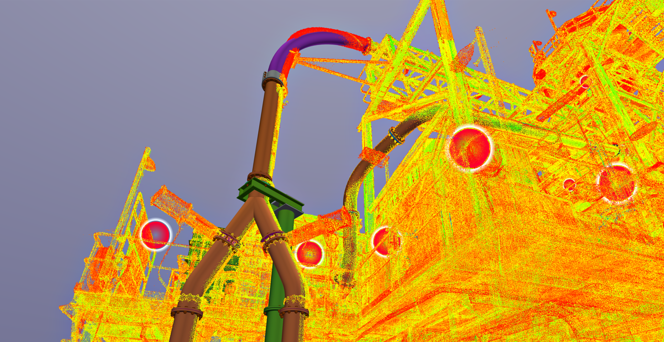
Now, laser scanners have the ability to capture more than one million three-dimensional measurements per second, with entire plants and mine sites scanned in a few minutes or hours, creating a “digital twin” of the infrastructure.
Reality capture, as it is called, creates a “digital twin” of the infrastructure or physical object, providing better visualisation and faster modelling on to a computer or a handheld device through the cloud.
Delonix founder and structural engineer Philippe Vatin says the speed and precision of 3D scanning is mind-boggling and the mining industry has captured on to this technology.
“3D scanning is the process of creating a digital model of the existing world using an automated process,” he said.
“We capture anything at a very high speed because the laser scanner machines pick up to two million points per second,” he said.
“That’s a lot of information and, because we are capturing so many points quickly, we can rebuild a three-dimensional model efficiently by mapping all these closely-spaced points together on a computer.”
The process of 3D scanning involves capturing three-dimensional attributes of a physical object, including its shape and texture, through methods such as laser scanning, structured light and photogrammetry.
Data is recorded from the surface of the object using a 3D scanner, which creates a “point cloud” of data, or a photorealistic cloud of points, from the object’s surface, with the information then processed to construct a digital 3D model from its 3D mesh of points.
Using the combination of laser-based and photo-based tools, this laser technology provides a more accurate and precise outcome than traditional surveying.
“Delonix uses predominantly Leica equipment and technology as we believe they are the best in LiDAR scanning at the moment,” Mr Vatin said.
“We are able to scan from an accuracy of 50-micron, useful for reverse engineering a mechanical part, all the way up to a few millimetres, as well as capturing full site and ground topography for plant design.
The earliest known use of 3D scanning was in the medical field in the 1960s.
Its use then evolved to the entertainment industry, where 3D scanning is still being used to create digital models for movies and backdrops for video game, such as the wildly popular Fortnite and Call of Duty.
Over time, this technology has become more refined, accurate and affordable, with the mining industry using it to create digital 3D models of entire mine sites and processing plants.
Mining majors are now using 3D scanning and reality capture to improve safety, productivity and data accuracy.
Delonix currently services clients such as Pilbara Minerals, Northern Star Resources (for the KCGM Super Pit), Lynas Corporation, First Quantum Minerals, BHP and CBH, helping their operations improve some of the following through 3D scanning:
- Mine Planning and Design: 3D scanning accurately maps and models existing mine structures and geology, providing necessary detail for efficient mine planning and design, as well as creating virtual reality models for improved visualisation and planning.
- Exploration and Ore Body Modeling: High-resolution 3D scans helps create detailed ore body models, improving the ability to predict the location of valuable mineral deposits and design more effective mining strategies.
- Volume and Quantity Surveys: 3D scanners provide quick, accurate volume measurements, allowing for precise inventory management and ensuring accurate calculations for financial reporting and planning.
- Equipment Maintenance and Inspection: 3D scanning creates detailed models of mining machinery and infrastructure for predictive maintenance, troubleshooting and planning upgrades.
- Safety and Risk Management: By scanning the mining environment, potential risks can be identified and mitigated, for example, identifying areas of potential ground movement or instability through regular 3D scanning.
- Restoration and Reclamation: After a mine is closed, 3D scans can help in planning and documenting the restoration process, ensuring that the land is returned to its original state or to a state that’s suitable for new uses.
The high degree of precision offered by 3D scanning, combined with the ability to handle large-scale projects quickly and efficiently, makes it a valuable tool for the mining and resources industry.
“You can get the centreline of two bolts, or the diameter of a hole, or you can get all the finer details of any surface, even curvature, limitation, damage… everything basically,” Mr Vatin said.
“What used to take about half-an-hour, as well as logistical challenges involving elevated work platforms and staff abseiling down the side of a building, now only takes a few seconds with a 3D scanner on a tripod or on the ground.”
Mr Vatin says few companies, however, have the ability to capture full-size plants in detail.
“The technology is currently being used in other fields on a small-scale as it requires significant IT infrastructure to handle the big data swiftly and simultaneously, not including the technical skills required to maintain the large amounts of data,” he said.
“Delonix has bucked the trend and made significant investment in this direction.”
Delonix Solutions has bundled together all of its scanning services under a single brand called RealClouds, which enables clients to work with point cloud data easily.
RealClouds provides cloud hosting of client data, as well as device streaming to workstations or held-held mobile devices, allowing clients to visualise or add notes, photos or models to their digital twin on-the-go.
RealClouds also maintains, updates and backs up all of the data and information, which is typically well over a few terabytes for most large clients.
“We handle all the big data associated with 3D scanning through our cloud server, called RealClouds, where clients can log-in, visualise and maintain their point-cloud information from their remote workstation or hand-held devices,” Mr Vatin said.
“Our servers stream the images to clients’ iPhone, iPad or workstations, where they can easily use and interrogate large data sets that are well in excess of 1TB of data.”
Delonix, based in Perth, specialises in innovative computer-aided design engineering and its team of about 50 staff has experience in a wide range of surveying and mapping applications, including mine surveys, road and rail construction, industrial plants and more.
“The only thing we don’t do is underwater,” said Mr Vatin.


