A WA company, Loupe Geophysics, has developed a new instrument to map electrical conductivity in the near-surface to a depth of around 25 metres.
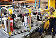
The instrument, called ‘Loupe’, is a backpack-mounted two-man portable system that measures conductivity over a range of depths while the operators are walking.
Data collection rates of around 5-6km per hour are possible.
Loupe Geophysics is a project founded by Greg Street and Andrew Duncan, two Perth-based veterans of the geophysical instrument business.
Mr Street has been working with geophysical systems in mining, groundwater and environmental applications for 40 years and Mr Duncan is the owner of Electromagnetic Imaging Technology (EMIT), the developer of equipment that has been responsible for a considerable amount of the recent geophysics exploration success in base metals exploration worldwide.
Mr Street said Loupe is a completely new type of electromagnetic (EM) instrument, with a wide range of applications.
“When we made a decision to build Loupe, there were no man-portable time-domain EM systems in the market,” he said.
“We decided to fill that hole by developing Loupe and we believe it is quite a special thing – the productivity and data quality is excellent. “The range of depths of investigation exceeds any of the man-portable systems out there and this system has the benefits of modern technology.
“Being a time-domain system, it can map electrical conductivity over a range of depths simultaneously and that’s a big point of difference – we’re able to analyse a complete cross-section of conductivity values as we walk along.”
Mr Duncan said that modern technology has added considerably to the capabilities of this instrument.
“Modern digital systems are incredibly powerful compared to the technology of a decade or two ago,” he said.
“We’re leveraging the power of modern semiconductors to sample very quickly at high resolution, to store and process a huge volume of digital data in real-time and to provide tools for the equipment operator and the geophysicist to help them make decisions about the survey.
“EM geophysics is increasingly being used in environments with considerable EM interference – in mines, industrial work sites and urban areas.
“There is interference from our electric world – this interference would have been very difficult to deal with in a system like this 20 years ago.”
The Loupe system has applications including:
- Mapping moisture in the walls of TSFs
- Mapping shallow sulphide mineralisation both in exploration and in-mine
- Mapping clay in iron ore
- Mapping volcanics in coal beds
- Mapping water filled voids such as old mine workings
- Mapping buried rubbish
- Mapping depth of weathering
- Mapping acid mine drainage
Features of Loupe include:
- A comfortable, adjustable carrying system that can be used in the field for long periods
- A web-based architecture so that the operator can log into the equipment with a handheld phone or tablet to view data and navigation information on a browser in real time
- Sophisticated signal processing leading to interference rejection and good performance in mining, industrial and urban areas
- Three-component receiver coil set with 100 kHz bandwidth allowing measurement from very shallow sources down to around 25m whilst walking
- Integrated with an RTK GPS system for accurate positioning
- The receiver samples up to 480,000 samples per second @ 24-bit allowing extremely high resolution spatially and with depth
- Real-time signal processing allowing the operator to see results in real-time and modify survey appropriately and,
- Storage that can deal with approximately 6 Mbytes of raw data per second

The Loupe system combines very high spatial and depth resolution with fast acquisition rates and survey speed.
Survey costs are significantly lower than other ground-based systems but data volume is vastly increased.
Small- to medium-scale projects can then be completed in very short timeframes – a survey looking for increased moisture in a tailings dam wall should take no more than one day.
In addition, the equipment can be packaged into two cases weighing less than 30kg each making air-freighting possible for urgent investigations.
Why map ground electrical conductivity?
Mapping electrical conductivity of the ground has been used for more than 100 years by scientists for a wide range of applications.
In the ground above basement rock, the variation in water content is the dominant factor controlling electrical conductivity, but changes in the salinity and pH of the water also change the conductivity. Increasing salinity can increase conductivity by factors of 100 to 1000.
Both low and high pH water can be as much two orders of magnitude more conductive than neutral water.
The next most important factor is porosity of the ground which varies from almost zero in crystalline rocks to around 50pc for some clays.
Thus, granite has very low conductivity and a clay much higher (assuming the salinity of the water held in the pore spaces is the same).
Sandstones, although more permeable than clays, contain less water and usually have lower conductivity and, because they are more permeable, usually contain less salt.
“On mine sites we deal with a range of mixtures particularly in the weathered zone (regolith) above basement rock,” Mr Duncan said.
“In a fairly uniformly weathered rock, we tend to see variations in the salt content causing most of the conductivity variation but changes in porosity also can influence the results.”
According to Mr Duncan, cavities or old mine voids will be very resistive if empty but may be quite conductive if filled with saline water.
“When mining iron ore, coal or base metals we want to know where the best material lies as well as the location of any hazards that might exist,” he said.
Considerable effort goes into defining the grades and hazards prior to, and during, mining.
A drill pattern to establish grade is common but even at very close spacing all the variability cannot be fully defined.
The Loupe system can map between, and potentially below drillholes, to help define the extent of sulphide mineralisation; clay pods in iron ore; volcanic intrusions in coal beds; or water-filled cavities.
Sampling every metre along traverses gives Loupe a high spatial definition.
Tests using the Loupe time-domain electromagnetic system
The company has carried out a series of tests on a range of targets and more are planned in the immediate future.
The Loupe developers have used a coastal suburban oval many times as a test site.
The oval has been constructed on an old waste burial site. Buried rubbish under the oval provides high conductivity targets in contrast to the surrounding sand dunes.
Infrastructure in the area (including houses, high voltage powerlines, traffic and buried cables) contributes significant EM interference to test the Loupe data processing.
In addition, the VLF communications station at Exmouth – which is one of the strongest radio stations in the world – sends out a booming signal right in the middle of the EM spectrum measured by the Loupe system.
These interference effects are effectively eliminated by smart processing in the receiver.
Surveys have shown that Loupe can derive, in one survey, a valuable 3-D picture of underground electrical conductivity.

A test was carried out on a shallow graphite deposit near Ravensthorpe.
In an hour the operators covered the prospect collecting around 5 kilometres of data. The Loupe survey showed very good correlation with drilling results.


Loupe electromagnetic system adds value to mining
A new generation of electromagnetic instrumentation developed in Western Australia shows great promise for a wide range of applications in mining and exploration.
It has the ability to add value in discovery, delineation, grade control and hazard mapping.
It also has the ability to home in on potential defects in TSF walls and levee banks as well as map groundwater problems such as acid mine drainage.
For more information visit: www.electromag.com.au


