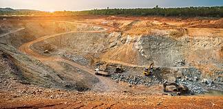
UAV Magnetics is at the forefront of drone surveying in Australia, and has refined its technology and method to create a system that is fast, efficient and produces high-quality, high-resolution magnetic data for exploration tenements and mine sites.
The system is the culmination of decades of expertise, and in conjunction with the custom magnetometer, is ideally suited for high-resolution magnetic surveys that are less than 2000 line km in size.
The custom-built hexacopter can fly autonomously at a range of 2km from the ground operator, and solves the significant safety risks associated with operating manned helicopters and fixed-wing aircraft at low altitudes.
The system can help to locate changes in rock types, and fault structures in the ground which provide critical information for mine operations and mine planning, such as dykes and coal operations.
Traditionally, collecting magnetic data over mine sites and exploration tenements involved two methods: a walking survey where the surveyor carries the magnetometer, or airborne surveys in a fixed wing aircraft or helicopter in a grid pattern.
Both of these methods have significant disadvantages associated with them, but these can be improved upon significantly with the use of unmanned aerial vehicles (UAVs).
Walked surveys are obviously quite slow.
The gear is heavy and cumbersome, and the terrain, temperature, accessibility and weather can all be prohibitively difficult for operators, amplified through the cost imposed by modern work, health and safety regulations which demand two operators working together on any one survey.
Helicopter and fixed wing aircraft do not have these problems; but they are far more expensive, and are limited to 40m above the ground for safety reasons.
This can be a severe impediment to the quality of data, as a magnetometer’s accuracy is dependent on its proximity to the ground.
UAVs provide the cost-effective, accurate, efficient solution to the problems of traditional magnetic surveys.
UAVs don’t have the same WHS operational requirements, and where a walked survey can cover about 15-20km per day, a UAV can cover 150-180km.
Where a helicopter cannot fly below 40m, UAVs can skim the ground at 10-15m with none of the operator hazards associated with manned aircraft.
This proximity to the ground gives the magnetometer a much larger amplitude and better responses than from a helicopter at 40m.
According to UAV Magnetics chief remote pilot Kyle Gardner, from a technical perspective, there are a number of advancements and factors that have led to the availability of high quality UAV surveys.
The first is that the UAV technology has advanced significantly in the past two years, with much of the technology filtering down from the military.
“Today, we operate large hybrid petrol-electric UAVs that have a payload capacity of up to 5kg, and an endurance of 90 minutes,” Mr Gardner said.
“These performance figures, together with advancements in the flight control, flight planning and data link technology, have only recently become available to the UAV industry.
“This means we can cover significant amounts of ground each flight, and our turnaround time is about 20 mins to refuel and upload a new flight plan.
“It’s quick and we’re not continually charging batteries.”
With a 25kg take-off weight and a hybrid petrol-electric setup, Mr Gardner is confident that UAV Magnetics’ custom hexacopter is competitive with, if not better than, most operational systems in the country.
With the petrol motor charging the batteries in-flight, the airborne insurance is extended to 90 minutes – significantly longer than a battery-powered drone.
Mr Gardner said that while it is new technology, it has been proven to be effective, and it is exponentially more efficient than both of the previous methods.
“We are proven against fixed wings and ground surveys,” he said.
“We are much more efficient at small to medium sized surveys, we fit nicely between the two and can provide very accurate data.
“We had only been flying flying for five minutes, and we had a supervisor with us and he said, ‘what you guys have done in five minutes would have taken me two hours’.”
UAV Magnetics chief geophysicist Anton Rada said that the second component in the survey, the magnetometer, had been refined and customised by UAV Magnetics through the data acquisition system (DAS).
The company’s specialised proprietary miniaturised acquisition system and sensor has been specifically designed for use with UAV’s.
“The traditional magnetometers are very heavy and bulky,” he said.
“Over the past four years we have continued to stay ahead of the curve, to stay in front of the new emerging technologies, and we have become a world leader in UAV magnetic surveys.
“UAV Magnetics is focused on providing the best data quality to ensure the client gets the best information and results, and I am yet to find an operator who can provide data that competes with ours.”
The data collected is used to determine the sub-surface structures, and to discriminate between the various rock types and geology beneath the surface.
Mr Rada said that this system has been the point of difference for the company, and that it had been overlooked by new players in the industry.
“We’ve seen a few guys coming into the market, and they have been developing their own systems, but we haven’t seen any of their data,” he said.
“We have seen some new start-ups and there are a lot of promises being made without a lot of delivery.
“Flying the UAV is perhaps the easiest part of the operation, and that is what people don’t understand.
“There is a bigger picture and people don’t see it: it’s the flight planning, the navigation, flying correctly to collect high-quality data.
“It’s not just the drone, it takes a lot to refine the processes and develop a system to the point that we have refined ours.”
Reflecting on the future of the industry, Mr Rada was excited about the advancements to come, and positive about the state of affairs as they are.
“The UAV Magnetic survey has proven that it can acquire superior data safely and economically,” he said.
“The future contains many ongoing refinements and improvements which will allow surveys to continue to be larger and more efficient, and even more automated.
“Major advancements are coming in the areas of longer range data links with more redundancy, higher endurance and payload UAVs, flying beyond line of sight, automated collision avoidance and advancements in sensor technology.”


