


Australia’s 2025-26 tropical cyclone outlook
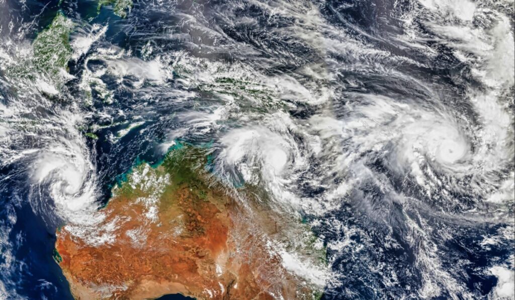
The Australian region is primed for severe tropical cyclones this season, despite an ongoing trend of reduced tropical cyclone activity over Australian waters in recent decades.
Australia’s tropical cyclone season officially runs from the start of November to the end of April. During this six-month period, the Australian region usually sees about 10 tropical cyclones, with about five of these becoming severe tropical cyclones (category three or higher) and four systems making landfall.
Tropical cyclone activity decreasing near Australia
The number of tropical cyclones that form in the Australian region each season has decreased in recent decades.
Since 1980, the total number of tropical cyclones per season has been reduced by about one system every 11 years. However, there has not been a similar drop in the number of severe tropical cyclones, which means the proportion of systems that become severe tropical cyclones (category three or higher) in each season has increased.
Seasonal tropical cyclone numbers are also influenced by El Niño and La Niña, with La Niña years typically producing more tropical cyclones near Australia and El Niño years often bringing fewer Australian cyclones.
The cause of Australia’s declining tropical cyclone activity in recent decades is an active area of research. It is likely due to a combination of natural variability and climate change.
What to expect this season
Tropical cyclone seasonal forecasts are difficult because there is usually a lot of variability from season to season. However, looking at how readily available the key ingredients for tropical cyclone formation will be in the season ahead can provide useful insights into what to expect.
The key ingredients for tropical cyclone formation are:
- Warm sea surface temperatures of 26.5°C or higher
- Low wind shear, meaning wind speed and direction doesn’t change too much with height
- An existing area of low pressure and convective activity (a cluster of thunderstorms)
This season will have plenty of warm water and convective activity to spawn tropical cyclones, thanks to above average sea surface temperatures surrounding most of northern Australia. A weak La Niña-like pattern and the tail end of a negative Indian Ocean dipole will also help maintain this abnormally warm tropical water near Australia early in the season.
However, this ample cyclone fuel will be counteracted by the background influences that have underpinned the long-term decline in cyclone activity near Australia in recent decades.
With all these factors considered, conditions are expected to favour a near to slightly above average number of tropical cyclones in the Australia region this season. There should also be a higher-than-average proportion of severe tropical cyclones, meaning that once systems do form, they have an increased risk of intensifying rapidly. More than half of the tropical cyclones that form in the Australian region this season could become severe, reaching category three or higher.
One of the most important things to understand about tropical cyclones is that it only takes one to have a big impact on industries, transportation and the landscape in northern Australia. Regardless of how many tropical cyclones form near Australia this season, if you operate in the tropics DTN APAC’s range of tropical cyclone services are there to support your business with tailored tropical cyclone information this season.
How DTN APAC is helping businesses prepare for the 2025-26 cyclone season
DTN APAC specialises in industry-leading forecast, alerting and threat analysis of tropical cyclones across Australia and Asia, offering you expert, customised solutions when the weather turns wild.
Providing rapid-update forecast information, DTN APAC alerts you to any low-pressure system gaining power within your region and, unlike other providers, can track its development out to seven days. This gives you the time to prepare and safeguard your staff, sites and assets.
You will have the most precise weather intelligence charting rainfall, wind speeds and potential storm surges to help you make critical decisions quickly. Whether it’s adjusting key work schedules, protecting your staff or securing your site, DTN APAC has the alerting capability to keep you steps ahead of the storm.
As the climate delivers increasingly severe weather events, their potential to impact your business operations grows.
Whether it’s preparing for the coming season’s tropical storm potential, or rapid-response forecasting with a typhoon approaching, or simply ensuring your operations team is equipped to confidently make decisions ahead of severe weather, DTN APAC’s weather Risk Communicators are here for you.
Its weather risk communicators deliver short- to long-term guidance from:
- Hourly-event weather monitoring (alerting you of impending destructive winds and heavy rain ahead of a tropical cyclone).
- Week to month operational planning based on likely timing of increased monsoonal rain or periods of reduced cyclone activity.
- Seasonal long term planning based on climate drivers and the likely trends across the coming months.
DTN APAC delivers clear and comprehensive weather data, personalised risk assessments and briefings to you and your team, so that your critical decisions can be made with confidence.
Its team is available 365 days a year, so you always have the timely guidance you require, especially when severe conditions hit.
You have DTN APAC’s insights to rely on to see you through complex situations, minimising potential loss of profit and maximising the safety of your staff and assets.
Learn more about DTN APAC’s large range of industry leading products and services.
