


Revolutionising exploration’s core
The value of the materials just below the surface can’t be understated — but it may not be entirely known either.
Whether determining exactly what our mineral resource is, estimating how much of this could be converted to mineral reserves, or calculating exactly how much these materials could be worth, there is no straightforward answer. One thing however is clear: when it comes to our commodities, these numbers are on an upward trend.
Our precious resources have massive realised and unrealised value. Consider that as early as 30 years ago, substantial drivers of demand like solar panels, electric vehicles and smartphones were still being conceptualised. But the enablers of these technologies, have been sleeping giants underneath our feet, just waiting for the moment to rise.
Critical for all commodities, exploration makes our newfound goals achievable.
If you follow the money, it’s clear exploration is essential. In CY24 alone, mineral exploration expenditure was $3.949b, with gold, iron ore and copper leading the pack.
Exploration expenditure in and around brownfields in 2024 was $2.823b and expenditure for undiscovered mineralisation in greenfields was $1.125b.
One of the most pivotal tools in mineral exploration is core logging. Brownfields drilling totalled to 7,129,600m?and greenfields drilling totalled 2,463,400m in CY24.
With such huge amounts of data in our hands, we must ensure it is handled with care.
The foundation of our resource understanding is core logging. Core logging defines the viability and potential of an ore body, but is an often time-consuming, solitary and subjective process.
Drill core logging is dominated by traditional and cumbersome practices such as pen and paper logs and spreadsheets. This means that much-needed contextual information is often buried in databases and printouts that are rarely referred to or connected to other data points.
Additionally, logging standards can vary between organisations and individuals leading to inconsistencies in data output and poor archiving practices, and valuable time is burned on data entry and conversion.
Geologists are in need of functional methods to incorporate multiple streams of objective drill core and borehole data into the logging process. There is also a need for tools that can reliably and efficiently analyse or contextualise complex data to support rapid decision-making.
Australia’s national science agency, CSIRO, is pioneering options that will empower the geologists that hold our future in their hands, with technologies such as LogAR and Data Mosaic.
CSIRO digital lead & senior engineer Sam Bradley and CSIRO geospatial research scientist Rebecca Montsion speak with the Australian Mining Review on the potential of these tools and the future of core logging.
LogAR
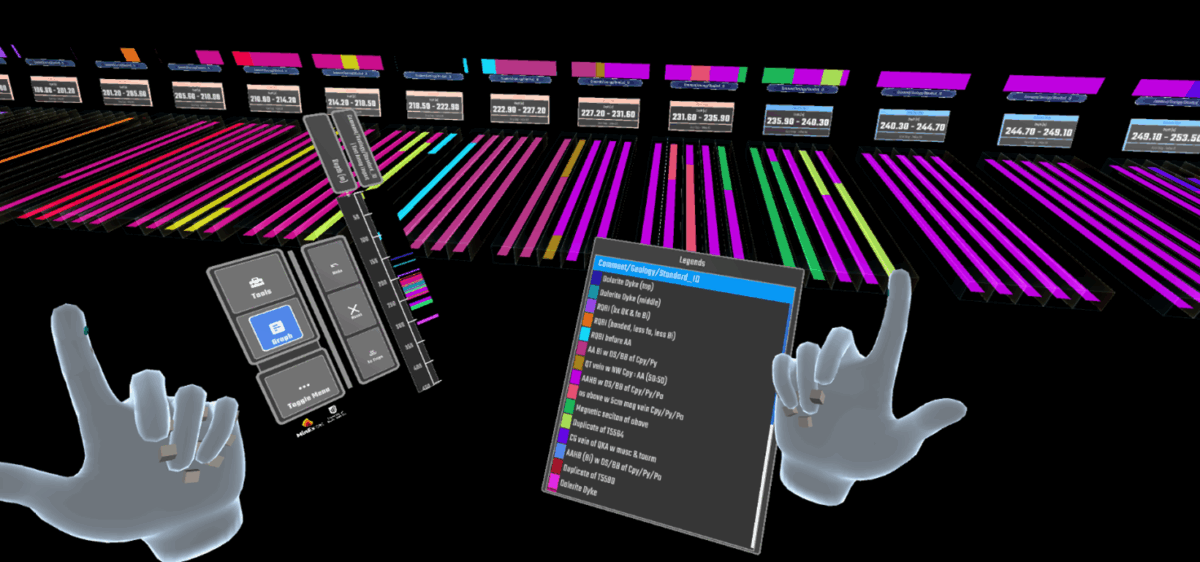
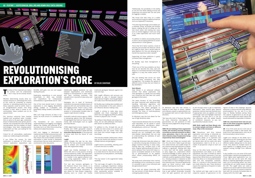
LogAR changes the way we see data, literally. The tool provides a revolutionary way to analyse and visualise borehole data, with augmented reality.
Commercialised by MinEx CRC, the application visualises data over borehole logs wherever it is needed, in-situ against physical core trays using augmented reality or with traditional 2D and 3D plots.
This tool also connects geologists to the National Virtual Core Library or to custom imported user data, unlocking much-needed contextual information. It also allows for Data Mosaic integration, allowing users to create and modify multiscale geological datasets against the real core trays.
With LogAR, efficiency and accuracy are improved as data is elevated beyond observational insights, meaning geologists can make more informed decisions faster.
Mr Bradley says making data available and easily interpretable to the point where it can influence decision making is key.
“LogAR is aiming to make data more available and more meaningful from within the core logging workflow by adding context to physical core,” he said.
“By adding in Data Mosaic and using it correctly, we can add additional information with almost no additional effort.
“In addition to this, through the use of a tablet we have access to a camera and microphone and can create richer logs and notes that include images and voice recordings.
“The tool also enables collaboration, where logs can be shared and worked on across multiple devices and geologists.”
LogAR centres accessibility, allowing users to access the tool on a tablet.
“There are several reasons why a tablet is an ideal device for this kind of tool and has become our lead platform,” Mr Bradley said.
“The top reason is the augmented reality capability.
“The real magic of LogAR is the ability to enhance a geologist experience viewing real physical core with data, which requires a device with a good quality camera and other positioning sensors available in modern phones and tablets.
“Additionally, the portability or the ability to use the tool while walking around and inspecting core paired with the and tools for logging is notable.
“We found that data entry on a tablet works well and supports additional devices such as a keyboard if necessary.
“The other big advantage is that tablets are a relatively cheap, accessible and familiar device, making the job of rolling out this tool much easier and making use cases such as remote logging or even just using it as a data exploration tool much more viable.
“In addition to tablets and possibly phones in future, we are paying attention to recent advancement in smart glasses.
“Once that form factor reaches a level of maturity and provides the features critical for LogAR to work, then it would make an ideal platform for this tool allowing for a hands-free experience when needed.”
Supporting all these platforms is good, consistent data management.
Mr Bradley says data management is everything.
“That’s one of the key problems we face: how do we describe this data, well and keep it in a consistent format to link things together in a way that makes sense?” he said.
“We are tackling that across our tools to bring more consistency into data management. This enables the upload of different kinds of data that are linked on key identifiers.”
Data Mosaic
Data Mosaic is an advanced software solution that allows exploration and mine geologists to rapidly and accurately turn numerical drill hole data into useful geological information.
The latest iteration of this technology has been improved with additional data handling, alternative algorithms and integration with other tools via the XT Workbench. This allows geologists to identify geological features of interest amongst the noise of multi-disciplinary and heterogenous data.
Dr Montsion says the tool allows for the use of high dimension data.
“Spectral-based datasets that are normally used separately can be paired in space with geochemistry, petrophysics, down-hole geophysics, and so on,” she said.
“The high dimensionality is a game changer because you can investigate and utilise inter-dataset relationships that are vital to understanding the subtleties of each geologic setting.
“Using high dimension data also allows us to overcome missing data limitations that plague machine learning. In many cases, missing data (e.g., samples from a drill hole, irregular spacing along drill holes, or entire datasets from some drill holes) requires incomplete datasets to be thrown out or generalisations to be applied, which causes compounding effects on outputs.
“By using more information than normal, and allowing it all to contribute to a result, it is possible to get a more informed and less generalised result.”
These tools are always improving, with the new version of Data Mosaic currently undergoing alpha testing.
Dr Montsion says this new version is looking at new ways to assess, validate and evaluate outputs so geoscientists can be equipped with tools to make informed decisions.
“We have also built in features that allow for more interactive interrogation so geoscientists can ask questions of their data and value judgements along the way,” she said.
AMR: We are looking at how augmented reality and machine learning solutions currently are and will continue to affect mine operations. How is the cost and time-intensive step of exploration being impacted by these technologies?
RM: I think two things are involved with this. First, the time it takes to get old data into useful formats and usable shape for any machine learning/exploratory analysis method is significant. Dealing with data is more than half the battle, especially at early stages (i.e., exploration) where minimal knowledge of what is going to be important is available. Some data science methods could be applied to either fill gaps (i.e., missing analyses or datasets) as well as clean data in a more intelligent and less time-intensive way. This would significantly speed up those onerous early stages without inserting too much bias.
The second thing related to this is knowing how to get started. Essentially, knowing what the right questions are and how to sift through noise to get to important information. Data science goes beyond predictive machine learning methods and, if appropriate tools are applied, can help sift through noise and highlight important information. The best part is it can do this efficiently with the added benefit of confidence measures, so you can quantitatively evaluate results.
AMR: Both LogAR and Data Mosaic aim to connect people and data in different ways. Why is this necessary?
RM: Geoscience, and thus mineral exploration and mining, is inherently an artistic science where experience plus imagination allows us to represent vast volumes of Earth in useful ways. How we decide what will be useful and what representations need to do for us is a matter of perspective unique to each use case.
Data, on the other hand, constrains our representations and allows us to refine hypotheses. But data is limited by where it is from and what it represents. It can’t go beyond that. While there are mathematical tools that allow us to interpolate between data and also extrapolate outwards, there is a myriad of micro-decisions that are made along the way. These decisions require the experience of experts to make value judgments.
The method and logic used to join the subjective aspects of geoscience to the rigours of data is the challenge, because everyone is unique and will bring different preconceptions. So, our aim is to find ways to flexibly facilitate joining these two aspects of geoscience so we can get a more meaningful and useful output that would otherwise be impossible in isolation.
AMR: On a functional level, how are you able to link these programs together in the exploration toolkit?
SB: A lot of the work we do in the rest of the exploration toolkit is web based. We build a lot of web applications, and a lot of the functionality is server driven.
LogAR runs natively on the tablet, but it calls back to our API, meaning you can have multiple instances of LogAR running on different tablets talking back to the same server. This allows for multiple clients to work together in a logging session to see updates coming through from different.
It also enables us to use some of the tools and the higher-need processing algorithms. Those higher-need applications can run server side and via the same API. Data Mosaic is relatively lightweight and doesn’t take a lot of processing power, but that’s something we can easily expose through the API. The LogAR client can make a request to our server with the data it would like to use, and then it’ll receive a response back with the correctly formatted data to display within the client.